JASCO leads the NAVISON project – Mapping past and future shipping soundscapes of European seas
/As the European Union (EU) and bodies such as the International Maritime Organization (IMO) focus their efforts on the prevention of marine and atmospheric pollution by ships in support of the UN sustainable development goals, a primary quest is underway for the reduction of greenhouse gases (GHG) emissions and of continuous underwater radiated noise (URN) from the maritime transport sector. Mitigation measures – both operational (changes in routes, schedules, ship speed) and technical (improved propellers, hull designs, power plants) – are being sought to reduce these pollutants, and a variety of scenarios are envisaged for the evolution of shipping over the next few decades.
The ability to assess the effect on ocean noise of such operational and technological changes, against the backdrop of a steadily increasing demand for sea transport of goods and people, depends on the development of a reliable marine soundscape forecasting model. The European Maritime Safety Agency (EMSA), as part of its commitment towards greener shipping, has contracted a project named NAVISON – from the Latin navis, ship, and sonus, sound – to generate ship sound maps (soundscapes) for European seas: Baltic Sea, Black Sea, Mediterranean Sea, North Sea, and North-east Atlantic Ocean. Both hindcast maps, based on ship Automatic Identification System (AIS) records, and forecast maps, based on projected future shipping densities and mitigation scenarios, are being produced. The research is being conducted by a consortium of European organisations led by the German branch of JASCO Applied Sciences, together with its vessel noise control subsidiary DW-ShipConsult and the Maritime Research Institute Netherlands (MARIN). Started in January 2022 and scheduled to be completed in mid-2024, the work has just reached the milestone of producing pan-European maps of shipping noise from five ship categories – from cargo ships to tankers to passenger and vehicle ferries – for the hindcast period 2016 to 2023 throughout all EU sea basins, thus allowing meaningful comparison of results for the different regions over time. Modelling of these different ship types was achieved using a new source level model specially developed within the project.
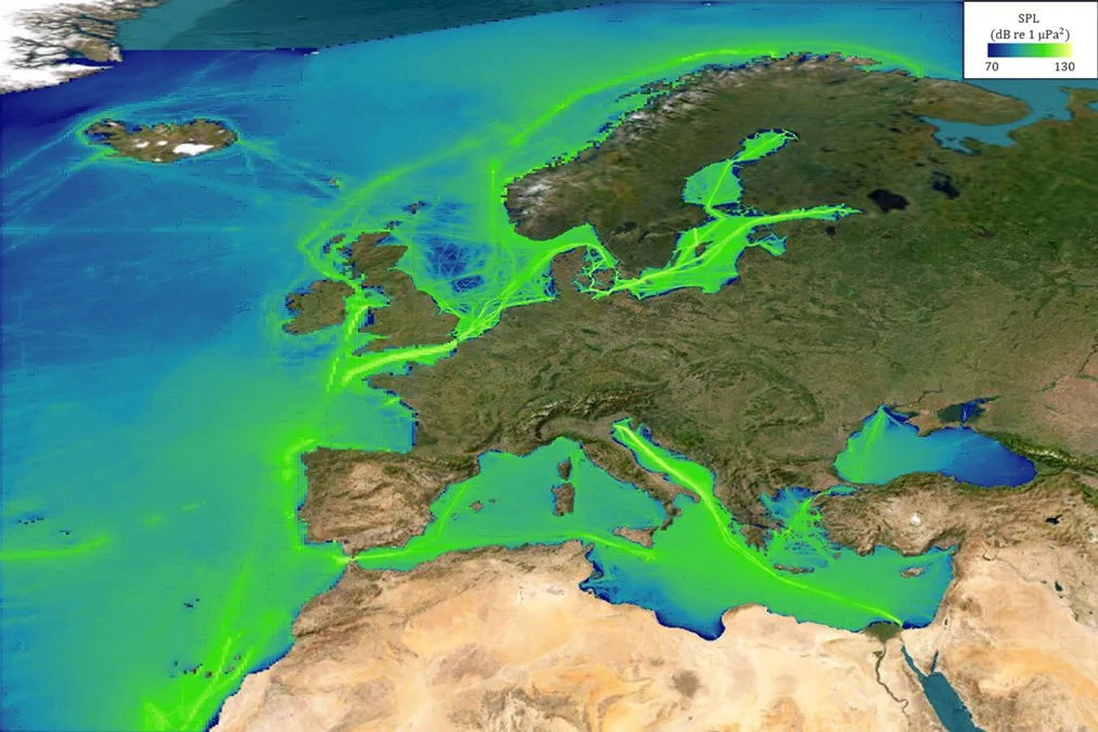
Key to the achievement of the project’s goals has been the ability to model efficiently the distribution of shipping noise from historical or forecast ship transit data at basin scales. The aim was accomplished by representing ship tracks as a spatial distribution of sound sources from which sound energy density was obtained after averaging in time and space. This novel modelling technique, developed by the study team, yields comparable accuracy to more established methods at a fraction of the computational time. The unprecedented spatial detail and geographic scale that have been made possible by the approach are evidenced by maps such as the one below, showing the modelled distribution of shipping sound for the first quarter of 2016 over the full extent of all European seas.
A hindcast map of the shipping soundscape at 63Hz in European seas for Q1 2016.
The project is now entering the stage of forecasting the evolution of shipping sound in European seas for the decades to come. Both operational and technical mitigation measures, aimed at URN and GHG reduction, are considered in these future scenarios. The study results will include three milestone years: 2030, 2040, and 2050, to cover short-, medium-, and long-term predictions up to the end of the current IMO GHG emissions roadmap timeline. A key new development is the ability to combine at will component sound map layers to produce forecast scenarios for multiple combinations of mitigation measures, enabling exploration of various adoption pathways. Mitigation measures affecting both cavitation and machinery noise (including speed reduction, propeller optimisation, hull design enhancement and biofouling management) are being examined in the modelling, phased in at different rates to account for their gradual implementation by the shipping sector.

